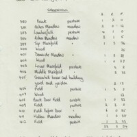
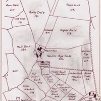
Maps/Data/Land Valuation 1832 / 1936 : Land Tithe Maps 1849
Dublin Core
Title
Maps/Data/Land Valuation 1832 / 1936 : Land Tithe Maps 1849
Description
Handwritten data & information for area around Greenhill
1. Land Valuations & maps dated 1832
2. Land Tax information : Tithe map/data 1936
3. 1849 Tithe Map Greenhill and various maps.
4. Ludworth Mill : information from Charter Rolls 1329
Miscellaneous material compiled and researched by Ann Hearle, former resident of Blackberries
1. Land Valuations & maps dated 1832
2. Land Tax information : Tithe map/data 1936
3. 1849 Tithe Map Greenhill and various maps.
4. Ludworth Mill : information from Charter Rolls 1329
Miscellaneous material compiled and researched by Ann Hearle, former resident of Blackberries
Date
Reviewed AB 12/2022
Identifier
PRO/04/05
Louiset
Louiset
Collection
Citation
“Maps/Data/Land Valuation 1832 / 1936 : Land Tithe Maps 1849,” Marple Local History Society Archives, accessed December 22, 2024, https://marplelocalhistorysociety.org.uk/archives/items/show/1452.

