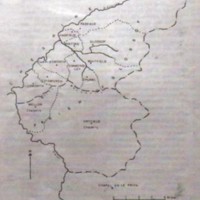
Map of Glossop Parish & Townships : Undated
Dublin Core
Title
Map of Glossop Parish & Townships : Undated
Description
Single photocopy document headed Parish, Manor and Townships with scale 1cm to 1 mile, showing Ludworth and Mellor Chapelry.
Page 34 from booklet entitled Glossop Dale, Manor and Borough published by the Glossop and District Historical Society 1973.
Undated.
Page 34 from booklet entitled Glossop Dale, Manor and Borough published by the Glossop and District Historical Society 1973.
Undated.
Publisher
J Andrew & Co Limited, Ashton-under-Lyne
Date
Reviewed AB 05/2024
Identifier
LUD/02/03
Louiset
Louiset
Collection
Citation
“Map of Glossop Parish & Townships : Undated,” Marple Local History Society Archives, accessed November 24, 2024, https://marplelocalhistorysociety.org.uk/archives/items/show/2189.
