Cataract Bridge Mill : Site and Location Maps : 1836
Dublin Core
Title
Cataract Bridge Mill : Site and Location Maps : 1836
Description
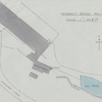
Hand drawn map showing Cataract Bridge Mill site with Mill Pond and stream by Tom Oldham
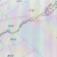
Photocopy of the 1836 tithe map showing Longhurst Lane / Cataract Bridge, but no mill.
Original map 'Indicative Masterplan' dated 29/07/04 showing the area of residential development on the Cataract Mill site which would not encroach within the Green Belt.
Photocopy of the 1836 tithe map showing Longhurst Lane / Cataract Bridge, but no mill.
Original map 'Indicative Masterplan' dated 29/07/04 showing the area of residential development on the Cataract Mill site which would not encroach within the Green Belt.
Date
Reviewed AB 02/2024
Identifier
MRS/06/05
Louiset
Louiset
Citation
“Cataract Bridge Mill : Site and Location Maps : 1836,” Marple Local History Society Archives, accessed December 4, 2024, https://marplelocalhistorysociety.org.uk/archives/items/show/2500.

